Log in
All resources
Create a design
684 Free Images of 1876 Maps
géographie générale; physique, politique et économique (1876)
the comprehensive history of england (1876)
english-language maps showing history
1870s maps showing history
charles eugène perron
1876 maps of africa
africa and its inhabitants, vol. ii
1876 maps of india
maps from the earth and its inhabitants, vol. ix
the geographical distribution of animals (book)
africa and its inhabitants, vol. ii
charles eugène perron
charles eugène perron
old maps of trabzon
the geographical distribution of animals (book)
australasia
norwegian north-atlantic expedition (1876-1878)
old maps of jan mayen
africa and its inhabitants, vol. ii
charles eugène perron
dr. wilh. junker's reisen in afrika 1875-1886
old maps of khartoum
africa and its inhabitants, vol. ii
charles eugène perron
maps from géographie illustrée de la france et de ses colonies
orientalist painting
historical
history
1876 maps of north america
1876 maps of the caribbean
austro-hungarian north pole expedition
maps of franz joseph land
africa and its inhabitants, vol. ii
charles eugène perron
maps of rivers of equatorial guinea
komo (river)
19th-century maps of nicaragua
bedford pim
french-language maps of south africa
1876 maps of africa
1876 maps of the united states
old maps of new england
dr. wilh. junker's reisen in afrika 1875-1886
1889 maps of sudan
old maps of the sea of galilee
french-language maps
the comprehensive history of england (1876)
english-language maps showing history
géographie générale; physique, politique et économique (1876)
19th-century maps of bretagne
géographie générale; physique, politique et économique (1876)
old maps of the strait of gibraltar
engravings from michael strogoff by charles barbant
illustrations from michael strogoff by jules férat
engravings from michael strogoff by charles barbant
illustrations from michael strogoff by jules férat
nouvelle géographie universelle, vol. xii
1890s maps of africa
africa and its inhabitants, vol. ii
charles eugène perron
africa and its inhabitants, vol. ii
charles eugène perron
maps from the earth and its inhabitants, vol. ix
old maps of samsun
nouvelle géographie universelle, vol. xii
old maps of saint-louis (senegal)
géographie générale; physique, politique et économique (1876)
1876 maps of india
géographie générale; physique, politique et économique (1876)
1876 maps of germany
géographie générale; physique, politique et économique (1876)
1876 maps of germany
géographie générale; physique, politique et économique (1876)
1870s maps of liguria
1870s maps of libya
ghadames
old maps of el hierro
history of el hierro
the comprehensive history of england (1876)
english-language maps showing history
géographie générale; physique, politique et économique (1876)
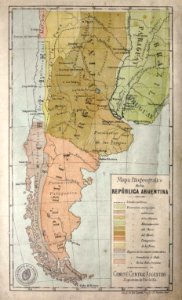
hydrographic maps of argentina
géographie générale; physique, politique et économique (1876)
1876 maps of turkey
géographie générale; physique, politique et économique (1876)
1876 maps of italy
géographie générale; physique, politique et économique (1876)
19th-century maps of pomerania
géographie générale; physique, politique et économique (1876)
18th-century maps of alpes-maritimes
géographie générale; physique, politique et économique (1876)
1870s maps of germany
1700s maps of germany
battle of blenheim
géographie générale; physique, politique et économique (1876)
1870s maps of china
nouvelle géographie universelle, vol. xii
old maps of la gomera
the comprehensive history of england (1876)
english-language maps showing history
the comprehensive history of england (1876)
english-language maps showing history
maps from the earth and its inhabitants, vol. ix
maps of beirut
elisabeth jerichau baumann
the comprehensive history of england (1876)
english-language maps showing history
maps from the earth and its inhabitants, vol. ix
old maps of baghdad
elisabeth jerichau baumann
rudolph striegler
nouvelle géographie universelle, vol. viii
1876 maps of india
the comprehensive history of england (1876)
english-language maps showing history
the comprehensive history of england (1876)
english-language maps showing history
the comprehensive history of england (1876)
english-language maps showing history
the comprehensive history of england (1876)
english-language maps showing history
the comprehensive history of england (1876)
english-language maps showing history
the comprehensive history of england (1876)
english-language maps showing history
1876 maps of south america
southern cone
panama in the 1870s
darién province
géographie générale; physique, politique et économique (1876)
old maps of the pyrenees
19th-century maps of somalia
1876 maps of africa
géographie générale; physique, politique et économique (1876)
1876 maps of europe
géographie générale; physique, politique et économique (1876)
1876 maps of africa
géographie générale; physique, politique et économique (1876)
1876 maps of south america
géographie générale; physique, politique et économique (1876)
1876 maps of europe
géographie générale; physique, politique et économique (1876)
1876 maps of north america
géographie générale; physique, politique et économique (1876)
1876 maps of asia
géographie générale; physique, politique et économique (1876)
1876 maps of asia
géographie générale; physique, politique et économique (1876)
1876 maps of india
géographie générale; physique, politique et économique (1876)
1876 maps of the united kingdom
géographie générale; physique, politique et économique (1876)
1876 maps of italy
géographie générale; physique, politique et économique (1876)
1876 maps of africa
géographie générale; physique, politique et économique (1876)
19th-century maps of borneo
géographie générale; physique, politique et économique (1876)
19th-century maps of the nile river
géographie générale; physique, politique et économique (1876)
old maps of rivers of france
géographie générale; physique, politique et économique (1876)
1870s maps of australia
géographie générale; physique, politique et économique (1876)
19th-century maps of java
géographie générale; physique, politique et économique (1876)
1870s maps of the atlantic ocean
géographie générale; physique, politique et économique (1876)
1870s maps of austria
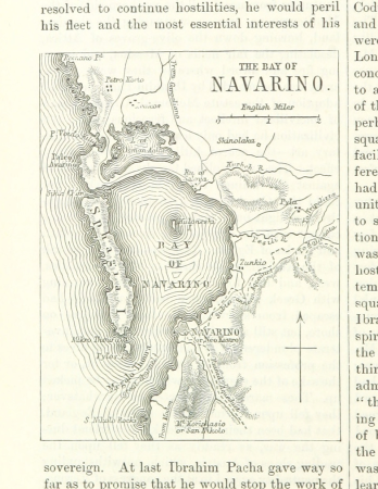
maps of the battle of the nile
battle of alexandria
the comprehensive history of england (1876)
english-language maps showing history
the comprehensive history of england (1876)
english-language maps showing history
the comprehensive history of england (1876)
english-language maps showing history
the comprehensive history of england (1876)
english-language maps showing history
the comprehensive history of england (1876)
english-language maps showing history
the comprehensive history of england (1876)
danube in 1704
the comprehensive history of england (1876)
english-language maps showing history
the comprehensive history of england (1876)
english-language maps showing history
1870s maps of cuba
guillaume le testu
the comprehensive history of england (1876)
english-language maps showing history
the geographical distribution of animals (book)
1876 maps of europe
ornament
maps
the geographical distribution of animals (book)
1876 maps of africa
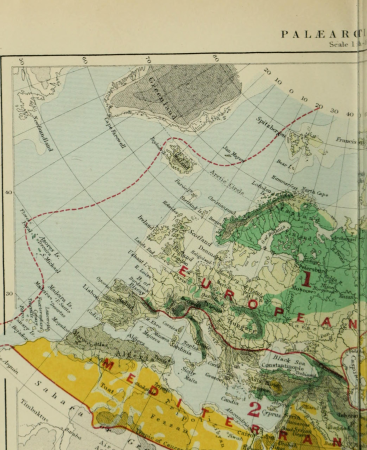
maps of the arctic ocean
maps of the north pole
the geographical distribution of animals (book)
1876 maps of the world
the comprehensive history of england (1876)
english-language maps showing history
the comprehensive history of england (1876)
english-language maps showing history
the comprehensive history of england (1876)
english-language maps showing history
the comprehensive history of england (1876)
english-language maps showing history
101 - 200 of 684
Next page
/ 7